Property of Philander and Thurza McCarter
in Grayson County, Virginia
New River Area Map
This map dates back to about 1832 when Philander bought his first property on Elk Creek. Through the years he accumulated more land eventually buying a second farm just over the state line in Ashe County, North Carolina.
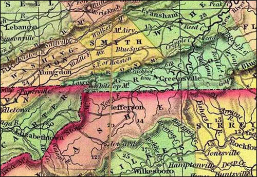
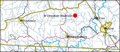
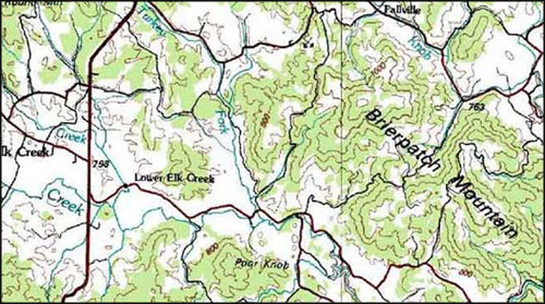
The following maps show the location of Philander and Thurza's farm on Elk Creek on Brierpatch Mountain. Some of the locals still refer to it as "McCarter Mountain."
1832 Deeds
On September 22, 1832, Philander McCarter of Grayson County bought $500.00 worth of land from Stephen Stone and wife Polly. The parcels were located on Elk Creek adjacent to Levi Cornutt's conditional line.
Grayson County Deed Book 6 pages 398 and 401
1835 Personal Property Tax List
Tithes |
Blacks 16+ |
Blacks 12-16 |
Horses |
Taxes |
2 |
0 |
0 |
2 |
.12 |
1850 Agricultural Census
| Acres of Improved Land | 200 |
Number of Horses |
4 |
Wheat |
30 bushels |
Hay |
9 tons |
| Acres of Unimproved Land | 300 |
Milch Cows |
10 |
Rye |
50 bushels |
Butter |
300 lbs |
| Value of Farming Implements | $125 |
Other Cattle |
10 |
Indian Corn |
200 bushels |
Cheese |
0 lbs |
| Value of Homemade Manufactures | $40 |
Sheep |
40 |
Oats |
350 bushels |
Wool |
75 lbs |
| Value of Agricultural Production | $150 |
Swine |
21 |
Peas and Beans |
1 bushel |
Flax |
116 lbs |
| Cash Value of Farm | $5,000 | Value of Livestock | $531 | Barley | 0 bushels | Flaxseed | 6 bushels |
1850 Land Grant
John B. Floyd, Esquire, Governor of the Commonwealth of Virginia: To all whom these Presents shall come -- Greeting: KNOW YE, That in conformity with a survey made on the sixteenth day of November, one thousand eight hundred and forty one, by virtue of Land Office Treasury Warrant No. 14,651 there is granted by the said Commonwealth, unto John Sutherland & Philander McCarter a certain Tract or Parcel of Land, containing six hundred and fifty acres lying and being in the counties of Grayson and Smyth (the greater part thereof in the former) on the waters of Fox creek, Holston [River] & Cripple creek bounded as follows, viz: Beginning at 4 lynns [linns] and a spruce pine [scrub pine] by a large branch of Middle Fox creek; Hence down said branch binding thereon S.15.E.88 poles to a spruce pine and 2 birches by said branch in a laurel near a small branch S.61.W.204 poles to a scrubby chesnut [chestnut] on the side of a hill N.12.W110 poles crossing the Iron mountain to five lynns on the North side of said mountain N.60.E.76 poles to a cucumber [magnolia], chesnut and maple N.22.E.136 poles to a chesnut and maple on the North side of a hill N.118.W.130 poles to a small hickory on the top of Canaday's ridge S.68.W.54 poles to a white oak and chesnut on the South side of a hill W.35.W.26 poles to two chesnuts from one root N.61.E.42 poles to two chesnuts from one root on the North side of a hill East 360 poles to a large water oak near a branch N.43.E.3 poles, crossing said branch to a water oak and chesnut N.85.E.118 poles to a water oak and two chesnut saplings from one root near a path S.15.E.56 poles to a birch, ash, and double birch in a branch 54 poles from the head of the branch at Richard's cabbins. Hence down said branch binding thereon to the beginning with its appurtenances
TO HAVE AND TO HOLD the said Tract or Parcel of Land, with its appurtenances, to the said
John Sutherland & Philander McCarter
and their heirs forever.
In witness whereof, the said John B. Floyd Esquire, Governor of the Commonwealth of Virginia, hath hereunto set his hand, and caused the Lesser Seal of the said Commonwealth to be affixed, at Richmond, on the thirty first day of August in the year of our Lord one thousand eight hundred and fifty and of the Commonwealth the twenty fifth
John B. Floyd
See the Library of Virginia for an explanation of Virginia Land Grants.
1860 U.S. Census
Value of Estate Owned |
||
Value of Real Estate |
Value of Personal Estate |
Total Value |
$4,500 |
$2,531 |
$7,031 |
1860 Agricultural Census
The family's farming practices were not unlike that of their neighbors. The chief difference was that they kept a few mules.
| Acres of Improved Land | 100 |
Wheat, bushels | 35 | Buckwheat, bushels | 45 | Other hemp products | 0 |
| Acres of Unimproved Land | 400 |
Rye, Bushels | 58 | Value of Orchard products | 50 | Flax, lbs. | 8 |
| Value of Farming Implements | $129 |
Corn, Bushels | 75 | Wine, gallons | 0 | Flaxseed, bushels | 7 |
| Cash Value of Farm | $4,500 |
Oats, bushels | 100 | Gardens, Value of market produce | $35 | Silk cocoons, lbs. | 0 |
| Number of Horses | 7 | Rice, lbs. | 0 | Butter, lbs. | 75 | Maple sugar, lbs. | 0 |
| Asses or Mules | 3 | Tobacco, lbs. | 0 | Cheese, lbs. | 0 | Cane sugar, 1000 lbs barrels | 0 |
| Milch Cows | 4 | Cotton bales | 0 | Hay, tons | 9 | Molasses, gallons | 0 |
| Working Oxen | 0 | Wool, lbs. | 69 | Clover seed, bushels | 3 | Beeswax, lbs | 5 |
| Other Cattle | 12 | Peas and beans, bushels | 0 | Grass seed, bushels | 0 | Honey, lbs | 20 |
| Sheep | 39 | Irish potatoes, bushels | 30 | Hops, lbs. | 0 | Value of homemade manufacture | $40 |
| Swine | 39 | Sweet potatoes, bushels | 0 | Dew rotted hemp, tons | 0 | Value of animals slaughtered | $140 |
| Value of Livestock | $550 | Barley, Bushels | 0 | Water rotted hemp, tons | 0 |
1863 Land Tax List
Location |
From C.H. |
Distance from CH |
Acres |
Value per Acre |
Value of Buildings
|
Total Value |
Total Tax |
Elk Creek |
NW |
10 |
50 |
$12.00 |
$200.00 |
$800.00 |
$6.00 |
Elk Creek |
NW |
10 |
100 |
$2.00 |
- |
$200.00 |
$2.00 |
Elk Creek |
NW |
10 |
114 |
$8.00 |
$100.00 |
$1012.00 |
$9.12 |
Elk Creek |
NW |
10 |
512 |
$2.00 |
- |
$1,024.00 |
$10.24 |
Elk Creek |
NW |
10 |
137 |
$1.00 |
- |
$137.00 |
$1.37 |
Iron Mt. |
NW |
15 |
473 |
.25 |
- |
$118.25 |
$1.18 |
TOTALS |
1386 |
- |
$300.00 |
$3,291.25 |
$47.84 |
||
1865 Farm Purchase in Ashe Co., North Carolina
On February 23, 1865, four months before the end of the Civil War, Philander purchased a 450 acre farm in Ashe County, North Carolina.
Sometime between this date and 1870, the family moved to this new farm.
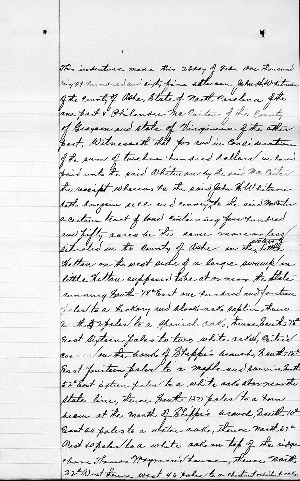
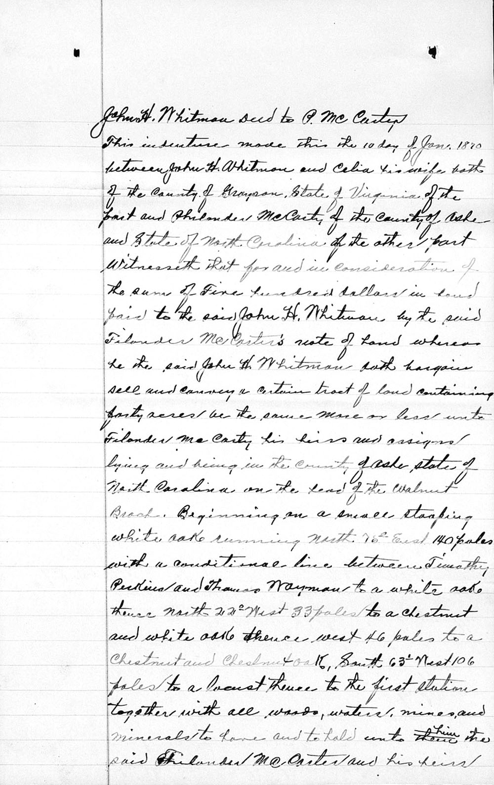
John H. Whitman Deed to Philander McCarter
This indenture made this 23rd day of February one thousand eight hundred and sixty five between John H. Whitman of the County of Ashe, State of North Carolina of the one part and Philander McCarter of the County of Grayson and state of Virginia of the other part.
Witnesseth that for and in consideration of the sum of twelve hundred dollars in hand paid unto the said Whitman by the said McCarter the receipt whereas to the said John H. Whitman doth bargain sell and convey unto the said McCarter a certain tract of land containing four hundred and fifty acres be the same more or less situated in the County of Ashe in the waters of Little Helton.
On the west side of a large swamp on little Helton supposed to be at or near the State running South 78° East one hundred and fourteen poles to a hickory and black oak sapling, thence North 52 poles to a Spanish oak, thence South 75° east sixteen poles to two white oaks, Carter's corner on the bounds of Shippe's branch, 15° East fourteen poles to a maple and _____ South 55° East sixteen poles to a white oak at or near the state line, thence South 150 poles to a horn beam at the mouth of Shippe's branch, South 10° East 44 poles to a water oak, thence North 57° West 40 poles to a white oak on top of the ridge above Thomas Wayman's house, thence North 22° West thence west 46 poles to a chestnut and chestnut oak sapling, thence South 63 ° West 106 poles to a locust on the top of hill, thence North 85° west 54 poles to three maples, thence north 90° west 30 poles to two hickories on the top of a nole [knoll] thence South 90° West 30 poles to a chestnut in Stephen Pennington's line, thence North 4° East with said Pennington's line to a chestnut Stephen Pennington's corner, thence north 26° west 40 poles to two spanish oaks, thence North 60° west 84 poles to a chestnut oak in the State line, thence with the state line to the first station.
Together with all woods, waters, mines - minerals to have and to hold unto him the said McCarter and his heirs free and assigns, to warrant and forever defend against all other claims unto the said Philander McCarter him and his heirs and assigns in witness whereas I have set my hand and sealed, signed, and delivered in the presence.
John H. Whitman (Seal)
Test
J. Perkins
Jesse F. Parsons
1870 Land Purchase in Ashe Co., North Carolina
One month before his death, Philander purchased another tract of land from John and Celia Whitman in Ashe County, North Carolina.
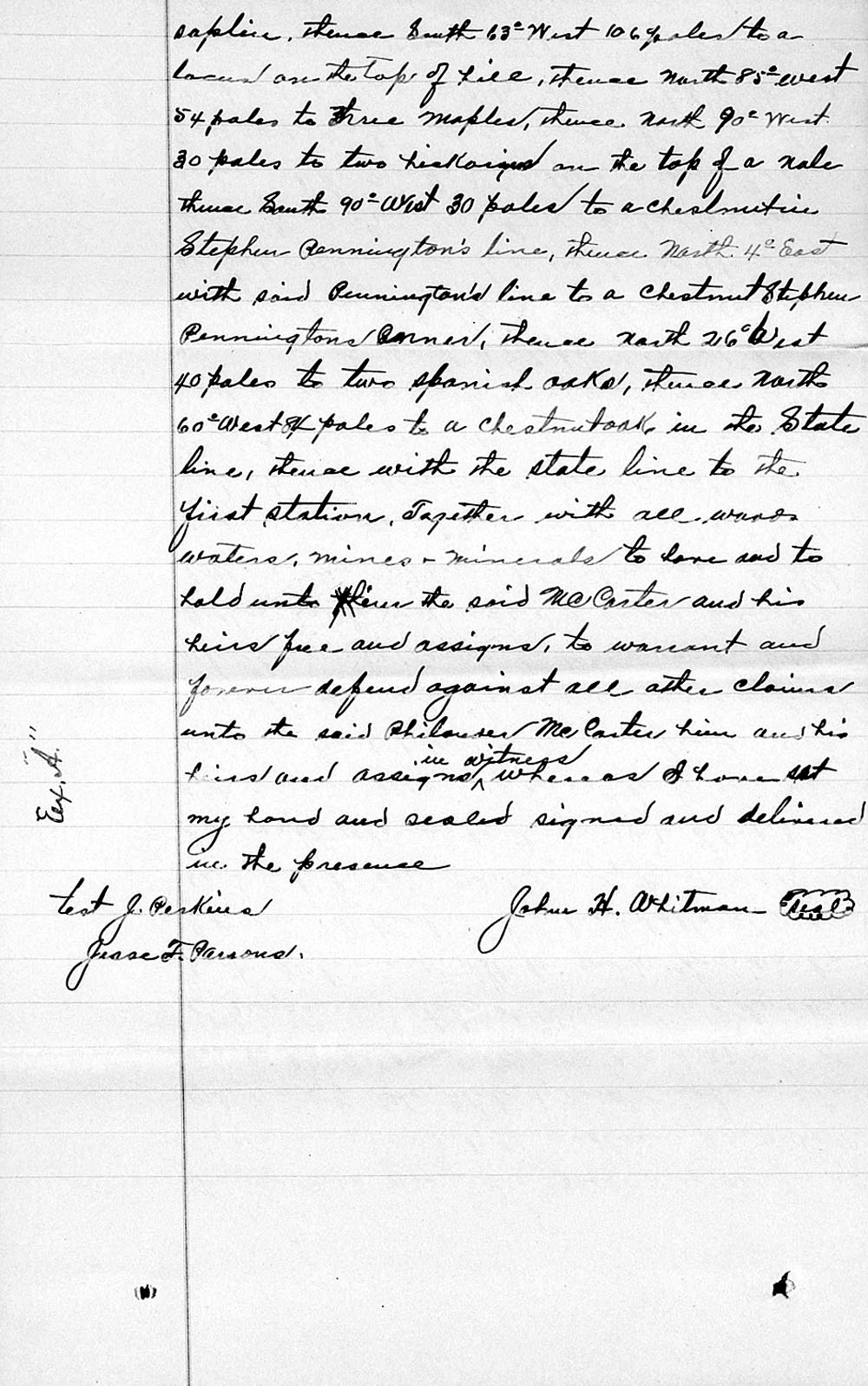
John H. Whitman Deed to Philander McCarter
This indenture made this the 10 day of Jan. 1870 between John H. Whitman and Celia his wife both of the County of Grayson, State of Virginia of the part and Philander McCarty [McCarter] of the County of Ashe and the State of North Carolina of the other part.
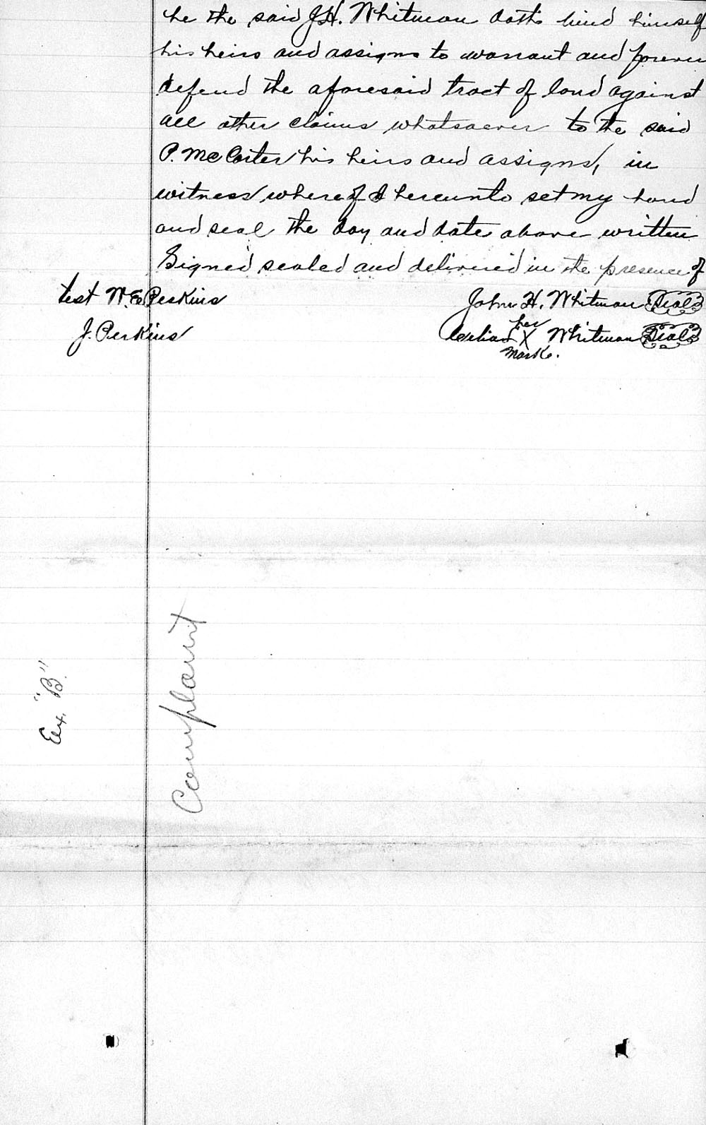
Witnesseth that for and in consideration of the sum of Five hundred dollars in hand paid to the said John H. Whitman by the said Filander McCarter's note of hand whereas he the said John H. Whitman doth bargain sell and convey a certain tract of land containing forty acres the same more or less unto Filander McCarty [McCarter] his heirs and assigns lying and being in the county of Ashe, state of North Carolina on the head of the Walnut Branch.
Beginning on a small _____ white oak running north 75° East 140 poles with a conditional line between Timothy Perkins and Thomas Wayman to a white oak thence north 22° West 33 poles to a chestnut and white oak thence west 46 poles to a chestnut and chestnut oak, South 63° West 106 poles to a locust thence to the first station together with all woods, water, mines, and minerals to have and to hold unto him the said Filander McCarter and his heirs he the said J. H. Whitman doth bind himself his heirs and assigns to warrant and forever defend the aforesaid tract of land against all other claims whatsoever to the said P. McCarter his heirs and assigns, in witness whereof I hereunto set my hand and seal the day and date above written.
Signed, sealed, and delivered in the presence of
John H. Whitman (Seal)
Celia (her X mark) Whitman (Seal)
Test
W. E. Perkins
J. Perkins
1870 U.S. Census (Ashe County, North Carolina)
Value of Estate Owned |
||
Value of Real Estate |
Value of Personal Estate |
Total Value |
$3,000 |
$800 |
$3,800 |
Property Values 1832 Through 1870
Year |
Total Value |
In Today's Dollars |
1832 |
$500 |
$13,100 |
1850 |
$5,531 |
$159,000 |
1860 |
$7,031 |
$190,000 |
1863 |
$3,173 |
$56,900 |
| 1870 | $3,800 |
$65,500 |